Chapter VI#
…Away Down South in Dixie… (1820-1830)#
A group of BERRY pioneers settled in Blount County Alabama at Brooksville in about 1815. Kenneth E. Lee, now deceased, published a history on this “set” of BERRY’S in 1981. In 1985, his brother Arthur C. Lee, published an additional book completed and up-dated on this “set” of BERRY’S.
The “set” of BERRY pioneers who settled in Fayette County have not been positively documented as being related to those BERRY pioneers who settled in Blount County Alabama. A relationship is suspected since they all came down from North Carolina about the same time.
What is known is that several BERRY pioneers, as early as 1822, got land grants in what is now Fayette County as the following information indicates:
| Date | Name | Resides In | Range | Township | Section | Source |
|---|---|---|---|---|---|---|
| 11-13-1821 | Berry, Gideon | Tuscaloosa Co | 9W | 21 | 12 | (XVI; p.8) |
| 1-2-1822 | Berry, Robert George | Tuscaloosa Co | nw | 16 | 12 | (XVI; p.11) |
| 1-16-1823 | Berry, Henry | Tuscaloosa Co | nw | 16 | 13 | (XVI; p.18) |
| 1-25-1825 | Berry, David | Fayette Co | nw | 16 | 5 | (XVI; p.22) |
| 4-7-1826 | Berry, John | Fayette Co | 12W | 16 | 12 | (XVI; p.26) |
There is not a Federal Census of Fayette County for 1820. Fayette was still part of Tuscaloosa County at this time. Information on the BERRY family reveals that Thompson Berry married Rosanah Gutman, June 5, 1824. Middleton (David) Berry married Dicy (Didma) Jones, September 12, 1825. (XXIII) David Berry is believed to be a brother to William C. Berry; also Thompson is believed to be a brother to William C. Berry.
Very few additional facts are known about the BERRY pioneers of Fayette County during the 1820’s. However, George Berry, believed to be a cousin to William C. Berry, had a voting precinct established at his mill in 1828. (XV; p.67) Henry, David & Robert are brothers while John is a cousin to William C. Berry.
These early BERRY settlers learned the meaning of Township, Range, and Section as they apply to the purchase & homesteading of land. An important law passed by Congress helped settle & organise into states, all the land in America except the Original 13 States & Texas.
The Land Ordinance of 1785
By this law (an ordinance is a law) the whole region (Northwest Territory) was divided into townships (each six-miles square). Each township was further divided into thirty-six (36) sections (640 acres), and numbered so that every piece of land could be located easily. To encourage education, the Ordinance provided that Section 16 in each township be set aside for the support of education. Also, Sections 8, 11, 26, and 29 were “Reserved for the United States”. The remaining sections were sold by auction at government land offices…
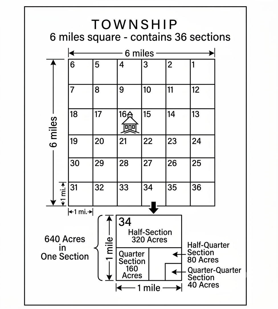
TOWNSHIP — 6 miles square, contains 36 sections. One Section = 640 Acres; Half-Section = 320 Acres; Quarter-Section = 160 Acres; Half-Quarter Section = 80 Acres; Quarter-Quarter Section = 40 Acres.
The Territory was to be governed in the following way:
(1) Officers were to be appointed by Congress
(2) When any section of the region came to have as many as 5,000 male settlers, it could organize as a territory, elect a house of representatives, and send one non-voting delegate to the Congress of the United States.
(3) When a territory grew to 60,000 free inhabitants, it could prepare a constitution and seek admission to the Union as a state with all the rights & privileges of the Original Thirteen States…
Another part of the Ordinance was a bill of rights. It: (1) guaranteed religious freedom to all denominations (2) protected the right of trial by jury (3) prohibited slavery (4) became the guiding law by which states were organized & admitted to the Union. Men could leave the older states knowing their political privileges would be protected on the frontier. (XIII; p.217)