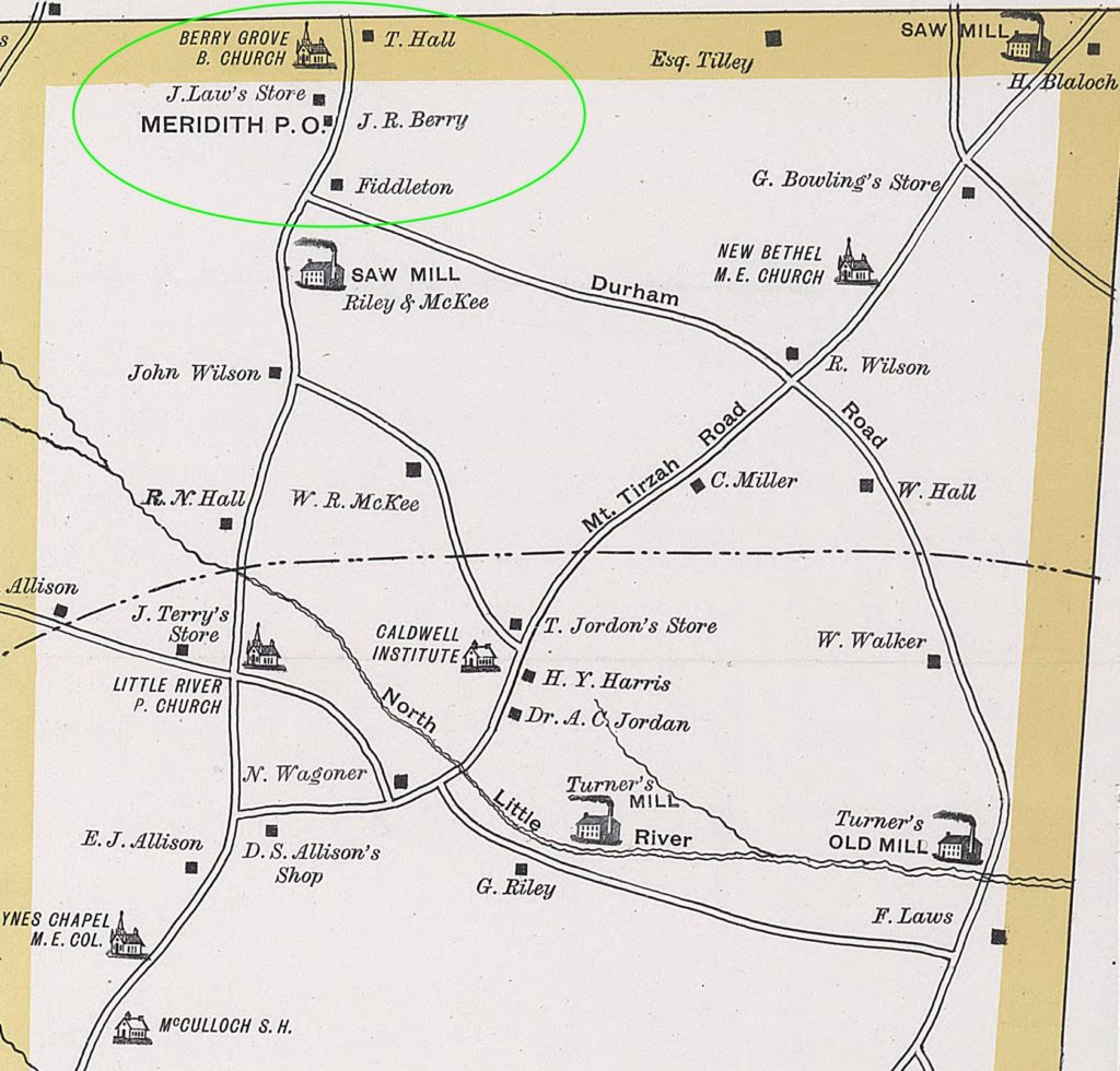
This is a map of Northern Orange County circa 1891 and published in 1940. Click on the image to get a full size map (large). It shows several Berry family landmarks, including John Robert Berry’s Homestead, The Fiddleton Plantation, Berry’s Grove Church and The Meridith P.O. which was located inside John Robert Berry’s General Store (Now located across the road from it’s original location). I have included the original source location and information below.
Why is this map with the name Fiddleton important? Robert Berry acquired his plantation in Orange County North Carolina in 1751 and apparently named his plantation Fiddleton. There is a Fittleton Wiltshire England 89.8 miles West of London. This is a strong indication that Robert Berry’s ancestors probably lived there.
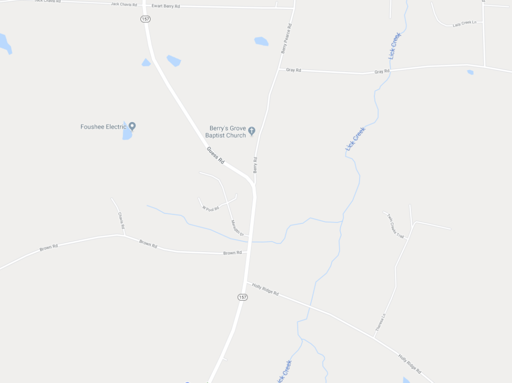
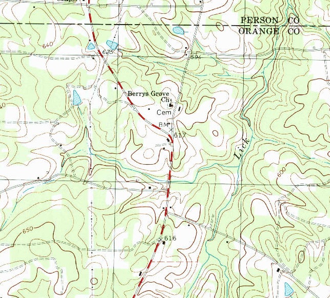
I have include modern maps of the same area at the bottom of this page.
Original Source Link: https://dc.lib.unc.edu/cdm/ref/collection/ncmaps/id/370
Original Source Information
Repository North Carolina Collection
Title Map of Orange County N.C.
Date Published circa 1940
Date Depicted 1891
Creator – Individual Tate, George W.
Moore, T. W. (Theophilus Wilson)
Place of Publication Bingham School, N.C.
Publisher George W. Tate
Caption “Published by George W. Tate, Bingham School N. C. Copyright 1891 by George W. Tate. Drawn by George W. Tate From Actual Surveys. T. W. Moore Photographer.”
Abstract Facsimile of 1891 original. Relief shown by hachures. Shows towns, roads, railroads, residences, schools, churches, mills, mines, natural features, roads, and railroads including the North Carolina Rail Road and Chapel Hill Railroad. Includes photographic portraits of “George W. Tate, Author of Map” “Professor J.H.McCracken, Principal of Caldwell Institute” “Dr. Kemp P. Battle, President U. of N.C.” “Hon. Wilie P. Mangum, U.S. Senator from N.C. 1887” “Hon. William A. Graham, Governor of N.C. 1845 &C.” Other photographs show “Memorial Hall U.N.C., Chapel Hill” “James A. Cheek’s Residence, Hillsborough” “Col. William H. Jordan’s Residence, Jordan Grove” “Dr. A.C. Jordan’s Residence, Caldwell Institute” “Caldwell Institute” “Cedar Grove Academy” and “Court House.” Townships shown include Cedar Grove, Hillsborough, Bingham, Chapel Hill, and Little River.
OCLC 52689788
Map Type General
Details
Businesses
Colors
Creeks and Streams
Houses
Landowners
Legends
Mills
Mines and Mineral Deposits
Photographs
Places of Worship
Railroads
Roads
Schools
Stores
Townships
Subject – Geographic Orange County (N.C.)–Maps.
Subject – Name
Tate, George W.
McCracken, J. H.
Battle, Kemp P. (Kemp Plummer), 1831-1919.
Mangum, Willie Person, 1792-1861.
Graham, William A., 1795-1856.
Cedar Grove Academy (Orange County, N.C.)
Caldwell Institute (N.C.)
University of North Carolina (1793-1962)
Subject – Topical Factories–North Carolina–Orange County–Maps.
Mines and mineral resources–North Carolina–Orange County–Maps.
Schools–North Carolina–Orange County–Maps.
Church buildings–North Carolina–Orange County–Maps.
Households–North Carolina–Orange County–Maps.
Subject (tgm)
Dwellings
Schools
Portraits
Places Depicted Orange County (N.C.)
West Longitude -79.266667
East Longitude -78.95
North Latitude 36.25
South Latitude 35.858333
Scale 1:42,240
Size 115 x 84 cm.
Medium Paper
Format Maps
Language English
Digital Collection North Carolina Maps
Institution University of North Carolina at Chapel Hill
Sponsor North Carolina Maps is made possible by the Institute of Museum and Library Services under the provisions of the Library Services and Technology Act as administered by the State Library of North Carolina.
Call Number Cm912.68 1891t1
Copyright This item is presented courtesy of the North Carolina Collection at the University of North Carolina at Chapel Hill for research and educational purposes. Prior permission from the North Carolina Collection is required for any commercial use.
Type Image
Verify 1923-1963_us , 1923-1963_unc
Modern maps of Berry’s Grove

Click the map above to go to the Google Maps page.

Click the image above to see the full size map Caldwell USGS Map. The link to the USGS site is here: https://ngmdb.usgs.gov/topoview/viewer/#15/36.2325/-79.0259
Last Updated 2020-02-10 William H.
